 |
Last Update:
Thursday November 22, 2018
|
| [Home] |
|
Volume 17 Issue 2 Pages 59 - 99 (October 2000) Citation: Yoxon, P. (2000) Geology and Otters IUCN Otter Spec. Group Bull. 17(2): 85 - 88 Paul Yoxon Skye Env Centre, Harapool, Broadford, Isle of Skye 1V49 9AQ, United Kingdom
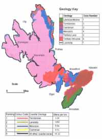
IOSF has undertaken eight years' research on the otter populations of the Isle of Skye and below is a summary of the findings. For the purposes of the study the island was divided into seven geological coastal zones based on maps from the British Geological Survey. In an initial survey of otter sightings in 1990 (YOXON and YOXON, 1990) it was found that certain coastlines favoured denser otter populations than others; it seemed that the geology of the coastline had an effect on this distribution with the Torridonian coastline having a much denser number than any other rock type. The island was divided into 500m coastal sections and the following variables were studied: coastal type, inland vegetation, slope of shoreline, width of the intertidal zone, otter activity per hour, number of holts, sprainting points, number of spraints and freshwater pools. 60% of the coastline was covered and data sheets completed for each section. Upon analysis of the data, certain predictable patterns emerged (YOXON, 1999): the Torridonian zone had a higher proportion of all the 'otter variables' than any other zone [mean numbers per 500m section (otters/hour = 2.4, holts = 0.4, sprainting points = 2.5, spraint numbers = 6.3 and freshwater pools = 1.4)] compared with the lowest numbers in the Tertiary Intrusive zone [mean numbers per 500m section (otters/hour = 0, holts = 0.04, sprainting points = 1.5, spraint numbers = 3, freshwater pools = 0.6)]. The increased activity on the Torridonian coastal zone is attributed to this zone having the greatest number of freshwater pools, a gently sloping shoreline with a boulder intertidal zone and native woodland adjacent to the High Water Mark. A map of otters per km is shown here together with the geology (Fig. 1).
Until now, little was known about the relationship between otter utilisation of the coastal zone and geology. On Shetland, MILNER (1978) categorised major coastal types and identified eight major coastal types using 81 physical and 18 geological attributes. CONROY and FRENCH (1985) classified the Shetland coast using over 200 attributes which were grouped into seven headings. Still on Shetland, KRUUK (1989) grouped the coast into six types based on evidence from maps, reports and prior knowledge of the area. He found a strong relationship between numbers of holts and peaty coasts with little agriculture and no high cliffs and a negative association between holts and tall cliffs. On Orkney there are few otters, in sharp contrast to Shetland, (KRUUK, 1995). This difference could possibly be attributed to distribution of prey species but it seems likely that Orkney shores are just as productive as those of Shetland. GREEN and GREEN (1997) stated, "that despite the productive nature of Orkney's fresh and coastal waters, the otter population was less dense than those of other island regions or parts of mainland Scotland". A more likely reason for the difference is the geology of the Orkney coast, which makes it a less suitable habitat for otters. The Torridonian sandstone on Skye is impervious and has very low porosity allowing freshwater pools to build up easily on the coastal fringe. By contrast, Devonian sandstone has a high degree of porosity and permeability (many oil reservoirs are present in Devonian sandstone), and so it would be difficult for freshwater pools to build up on these rock types in the same numbers as on the Torridonian sandstone. The Orkney landscape is composed of Devonian sandstone and is well drained with rich farmland. The low density of otters from Dunnett Head to the Moray Firth could equally be a consequence of the geology of the coastal fringes, which also consist of Devonian sandstone. REFERENCES Conroy, J.W.H., French, D.D. 1985.
Monitoring otters in Shetland. Shell Oil Terminal Report. Resumen: Geología y nutrias |
| [Copyright © 2006 - 2050 IUCN/SSC OSG] | [Home] | [Contact Us] |
