 |
Last Update:
Thursday November 22, 2018
|
| [Home] |
|
Volume 21 Issue 2 Pages Pages 60 - 101 (January 2005) Citation: Hubbard, B. and Serfass, T. (2004) Assessing The Distribution Of Reintroduced Populations Of River Otters In Pennsylvania (USA) - Development Of A Landscape- Level Approach. IUCN Otter Spec. Group Bull. 21(2): 63-67 Assessing The Distribution Of Reintroduced Populations Of River Otters In Pennsylvania (USA) - Development Of A Landscape- Level Approach Brett Hubbard and Tom Serfass Department of Biology, Frostburg State University, Frostburg, Maryland, 21532 (USA) (received 18th February 2005, accepted 24th February 2005)
During the 1970s, improvements in furbearer management techniques and water quality coincided with increased concern about river otter (Lontra canadensis) declines in North America ( ENDANGERED SPECIES SCINETIFIC AUTHORITY, 1978). Consequently, many wildlife management agencies conducted surveys to determine the status of river otters. Results of these surveys demonstrated that, in many cases, there was a need to implement conservation measures to restore or enhance river otter populations. Many of the conservation actions implemented were in the form of re-introduction projects ( RALLS, 1990). The first river otter re-introduction project was initiated in Colorado during 1976 ( TISCHBEIN, 1976). From 1976 to present, 21 states and 1 Canadian province (Alberta) have released >4,100 river otters through re-introduction projects. Monitoring initial fates of translocated wildlife and subsequent long-term studies to determine if self-sustaining populations become established should be an important aspect of re-introduction projects (SERFASS, 1994; IUCN, 1998). Unfortunately, there have been few formal studies, accompanied by published reports or other external documentation, evaluating short or long-term status of re-introduced river otter populations. ERICKSON & McCULLOUGH (1987), SERFASS et al. (1993 a ), and JOHNSON & BERKLEY (1999) reported favorable survival rates and persistence of river otters based on radio-telemetry studies conducted at re-introduction sites in Missouri, Pennsylvania, and Indiana, respectively. Pennsylvania developed survey strategies to enhance procedures to detect presence of river otter latrine sites for monitoring persistence of re-introduced river otter populations ( SWIMLEY et al. 1998). However, there have been no other published informations regarding long-term monitoring of river otter populations in North America. Since 1982, the Pennsylvania River Otter Reintroduction Project (PRORP) has applied an integrated, adaptive management approach to reintroduce 153 river otters successfully to seven water systems in central and western Pennsylvania. The project was comprised of five developmental and implemental stages:
which resulted in a successful, ecologically based, and publicly supported reintroduction project. PRORP is in the final phase of the reintroduction process and is focusing on the development and evaluation of long-term approaches for monitoring the reintroduced populations, as recommended by IUCN 1998 guidelines. Surveys to detect river otter sign (e.g., scats and tracks) have been demonstrated effective in determining the presence of river otters and will form the basis for the establishment and refinement of monitoring protocols. As part of the process of refining surveys, we have been considering four specific questions regarding the use of scats for monitoring river otter populations:
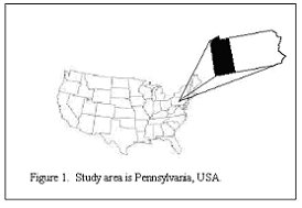
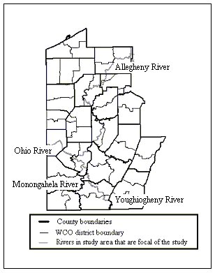
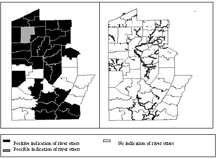
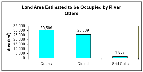
Landscape-level population monitoring: Europe had developed and implemented The Standard Method, a grid-based format for surveying otters at a landscape level (see REUTHER et al., 2000 for a detailed review of The Standard Method). This manner and place of its implementation across the continent is detailed in REUTHER et al., 2000. Unfortunately, no standardized methodologies have been developed for monitoring long-term trends in river otter distributions in Pennsylvania or elsewhere in North America. Consequently, we developed a GIS-based approach for application in monitoring the current and future distribution of river otters. Our initial efforts have focused on developing this landscape-level monitoring approach within the Allegheny River drainage, which comprises approximately the western third of Pennsylvania (Figure 1). Initially , interviews were conducted with Wildlife Conservation Officers (WCOs) of the Pennsylvania Game Commission (the agency responsible for the management of all avian and mammalian species in the Commonwealth) to determine the general distribution of river otters in the drainage. WCOs enforce wildlife laws in the state, are assigned to a specific district (usually 1-3 WCO districts for each county in the state; Figure 2) and generally are well informed about the occurrence of most large or unique mammalian species in their districts. The opinions of WCOs traditionally have been used to monitor the occurrence of river otters at their district and county levels ( SERFASS et al ., 1999). However, this coarse-level approach considerably overestimates the actual distribution of a habitat specialist, such as the river otter. Consequently, we modified a GIS-based grid system developed in conjunction with the Pennsylvania GAP Project (PAGAP, 2004), resulting in the creation of a statewide electronic grid comprised of 1 km 2 cells. WCOs subsequently were interviewed and asked to evaluate the presence or absence of river otters within each grid cell occurring in their respective districts. This level of evaluation provides a more realistic assessment of the distribution of river otters and provides a standardized approach for assessing expansion or contractions associated with river otter populations over time. The ease in which the grid can be filled in with information provided by WCOs about presence or absence of river otters (assuming the information they provide is reliable) offers potential to reduce the time and costs associated with intensive field studies. Also, each grid cell represents a sample unit and, therefore, facilitates quantification of landscape-level habitat features associated with the presence or absence of river otters. We are in the final stages of assessing the validity of responses by WCOs for the presence or absence of river otters within each grid cell. The validation process involves searching riparian habitats for the presence of river otter sign (primarily scats) during periods of peak scat marking (spring and fall). For selecting grid cells for inclusion in the validation process, we took a stratified random sample of all cells identified by WCOs as positive cells (considered occupied or likely occupied) and negative cells (considered unoccupied) in the southern portion of the study area (which included 10% of the positive cells and about 2% of the negative cells occurring within 10 km of a positive cell). When completed, we will have assessed 130 grid cells for the presence or absence of river otters. The validation process will provide considerable insight about the ability of WCOs to reliably predict the presence or absence of river otters at the scale established by the grid ( 1 km 2 cells). The results will therefore indicate if a relatively quick and efficient approach for assessing the distribution of river otters (WCO surveys) can supplant or supplement more time and labor intensive approaches (riparian surveys). Regardless of the technique used to assess the distribution of river otters, representing presence or absence data at the scale of our grid-based approach provides a much more realistic appraisal of the distribution of an organism, especially in the case of a habitat specialist such as the river otter (Figure 3,4). Results of our interviews with WCOs and associated riparian surveys demonstrate that river otters persist at all reintroduction sites in western Pennsylvania and that populations are expanding. Our goal is for the state natural resource management authorities (The Pennsylvania Game Commission and Pennsylvania Department of Conservation and Natural Resources) to adopt use of the grid-based approach described in this article for long-term monitoring of the reintroduced populations. ACKNOWLEDGEMENTS - We would like to thank the Pennsylvania Wild Resource Conservation Fund, a State Wildlife Grant Administered by the Pennsylvania Game Commission, and the U.S.D.A. Allegheny National Forest for funding support and our families for moral support. REFERENCES Beheler, A.S., Fike, J.A., Murfitt, L.M., Rhodes,
Jr., O.E., Serfass, T.L. 2004. Development of polymorphic microsatellite
loci for North American river otters ( Lontra canadensis ) and
amplification in related Mustelids. Molecular Ecology Notes 4 ,
56-58. Résumé :
Evaluation de la distribution de populations de loutres du Canada
réintroduites en Pennsylvanie (USA): Développement
d'une approche au niveau du paysage Resumen: |
| [Copyright © 2006 - 2050 IUCN/SSC OSG] | [Home] | [Contact Us] |


